Running the MoCo Watershed
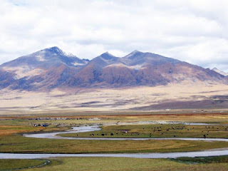
This mid-section of the mid-Atlantic state in which I live serves as a vast drainage area, sloping from the Blue Ridge and Appalacian areas in the west to the flat coastal plains in the east. A map of the MoCo (Montgomery County) watershed looks like the capillarized cross-section of some vital organ. As I suppose it is.
Today's planned 6-hour run begins in a dense early morning fog at the small parking area in front the ruins of Black Rock Mill. I am here, not the trailhead at Riley's Lock, where Seneca Creek flows into the Potomac, because with the soggy past week we've had and warm, almost spring-like January day, parts of the lower lying portion of the Seneca Greenway Trail will likely have turned to bog.


For the first half hour, I move slowly, warming up the legs and picking my way carefully along the muddy track. River and forest are wreathed in fog. The air is damp, cool but not cold--not a typical day for January. Along the riverbank there is new, almost springlike green growth in places. Fog and high winter quiet give the riverscape an oneiric quality.
The path, even the river itself, appear to have been rerouted, shifted by storm and flood. With the leaves gone, I can see the ravine walls and outcroppings of rocks that are invisible in the summer. Fallen trees litter the hillside. I feel curiously exposed. I think of Sir Gawain, travelling the winter-paths in reverse pilgrimage to his mid-winter appointment with the Green Knight.
For the first two hours of my run, I see no one. As the fog burns off and as I near Clopper Lake, I spot a bow hunter trudging noisily across a field into the woods. His brown camouflage hunting clothes stand out in stark relief against the pale dead winter grass.
I am always astonished how, in the heart of a county with a million residents, I can be moving through a landscape for hours without seeing anyone. Vital as it may be, the river feels detached from the lived world of shops, roads, and houses. Our congested roads no longer need to follow the logic of the old water-paths. Drivers are scarcely aware of the existence of these streams and creeks--except when they flood, or someone drowns. To run the trails of MoCo is to retrace the old paths and relearn the logic of rivers and streams.
I do a few loops around the root-studded, muddy lakeshore trail, dodging gnawed-off ends of trees and branches that beavers have rather wastefully (it seems to me) left scattered about. I am no longer alone on this trail, sharing it with a handful of other runners and a few lone walkers. Stopping briefly at a picnic table, I eat one of the guacamole wraps that are my sole source of calories for this run. The lake is gray in its midwinter ordinariness, but even at its drabbest, the combination of water and forest trail and motion inspire a strange excitement and anticipation in me. It is a sort of continuous low-level aesthetic buzz, providing nourishment for ultra-distance running as vital as food.
Four hours into the run, I have looped back to the car, where I switch off my minimalist Vivo Barefoot Breatho trail shoes for the somewhat less minimalist Inov-8 XT Talons. Both are ideal for the day's sloppy exigencies, but the cushionless Vivos have left my feet feeling just a tad raw. I may be recovering still from last week's Phunt 50k. By comparison, the hardly supportive Inov-8's feel cushy.

I head up the steeply graded road, then turn onto the beehive of Schaeffer Farm trails. I am quickly onto a path following the contours of a field. The path is red-orange--the utisol or red clay soil found from Alabama to Maryland, up and down the Piedmont, although less common in our area than in the South. Again I have the sensation of running not forwards but backwards into the past, into a vanished elsewhere.
Winter opens a landscape that for most of the year is hidden. The topography of Schaeffer Farms, half a mile from the Seneca Creek riverbed, comprises a complexly folded, corrugated area of 2000 acres. Designed for mountain bikers, the trails here can rollercoaster in a matter of minutes from muddy stream bottom to pine forest ridge line. Steep hills rise where hard igneous stone has weathered more slowly than the softer layers of sedimentary rocks below. One moment I am peering down a wooded declivity, minutes later I am wetting my feet in the creek at ravine's bottom.
Five and one-half hours--almost done. The sun is high and temperatures have risen into the fifties. I have stripped down to shorts and a t-shirt now, for the first time in months. Feeling rejuvenated, and glad to be near the end, I run out the clock with one more circuit of the white-blazed trail, then head back down the hill to Black Rock Mill.


Sounds like a pretty nice (long!) run through a primeval landscape. I wonder what it would look like if you really could run back through time. I wondered that on my hour run through rural Iowa yesterday. The once beautiful and diverse prairies and oak savannas have mostly been appropriated and transformed by farmers. It still has a beauty to it, though. We will work hard to continue resoration of our little plot.
ReplyDeleteHope I have a chance to accompany you on one of those rural Iowa runs sometime. There must be many pathways & pastways in your area too--perhaps traces of the old prairies are still there, if you can find them.
Delete